


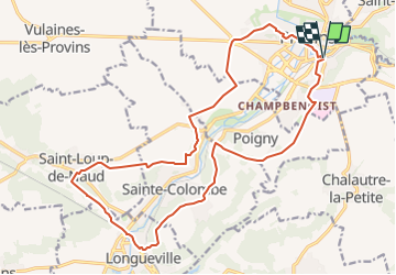
De Provins à Saint-Loup-de-Naud en boucle

les randos d'Olivier
partout a pied et en moto

Length
19.8 km

Max alt
153 m

Uphill gradient
322 m
Km-Effort
24 km

Min alt
69 m

Downhill gradient
322 m
Boucle
Yes
Creation date :
2024-02-23 07:08:43.251
Updated on :
2024-02-23 07:26:52.068
5h27
Difficulty : Very difficult

FREE GPS app for hiking
 SityTrail
IGN / Geographical institutes
SityTrail Plus
The world is yours!
About
Trail Walking of 19.8 km to be discovered at Ile-de-France, Seine-et-Marne, Provins. This trail is proposed by les randos d'Olivier.
Points of interest


Positioning
Country:
France
Region :
Ile-de-France
Department/Province :
Seine-et-Marne
Municipality :
Provins
Location:
Unknown
Start:(Dec)
Start:(UTM)
522425 ; 5378137 (31U) N.
Comments