


Lussas : Oppidum de Jastre -Camp de Cesar14km.

chancha
User GUIDE
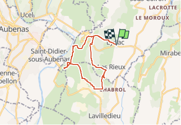

Length
15.2 km

Max alt
368 m

Uphill gradient
244 m
Km-Effort
18.5 km

Min alt
261 m

Downhill gradient
241 m
Boucle
Yes
Creation date :
2024-02-23 12:19:52.701
Updated on :
2025-01-28 13:21:11.937
4h11
Difficulty : Difficult

FREE GPS app for hiking
 SityTrail
IGN / Geographical institutes
SityTrail Plus
The world is yours!
About
Trail Walking of 15.2 km to be discovered at Auvergne-Rhône-Alpes, Ardèche, Lussas. This trail is proposed by chancha.
Photos


Positioning
Country:
France
Region :
Auvergne-Rhône-Alpes
Department/Province :
Ardèche
Municipality :
Lussas
Location:
Unknown
Start:(Dec)
Start:(UTM)
616855 ; 4940927 (31T) N.
Comments