


couteliere

Famille Depaix
User
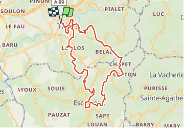

Length
21 km

Max alt
758 m

Uphill gradient
791 m
Km-Effort
31 km

Min alt
359 m

Downhill gradient
791 m
Boucle
Yes
Creation date :
2024-02-25 07:28:57.865
Updated on :
2024-02-25 15:57:43.554
8h27
Difficulty : Very difficult

FREE GPS app for hiking
 SityTrail
IGN / Geographical institutes
SityTrail Plus
The world is yours!
About
Trail Walking of 21 km to be discovered at Auvergne-Rhône-Alpes, Puy-de-Dôme, Thiers. This trail is proposed by Famille Depaix.
Positioning
Country:
France
Region :
Auvergne-Rhône-Alpes
Department/Province :
Puy-de-Dôme
Municipality :
Thiers
Location:
Unknown
Start:(Dec)
Start:(UTM)
542264 ; 5078294 (31T) N.
Comments