


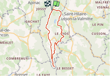

12.5 km | 16.3 km-effort


User


FREE GPS app for hiking
 SityTrail
IGN / Geographical institutes
SityTrail World
The world is yours!
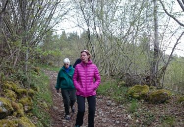
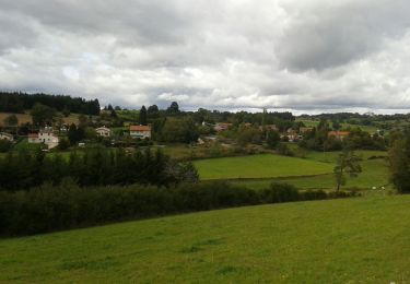
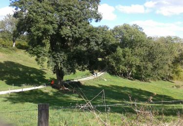
Trail Walking of 14.4 km to be discovered at Auvergne-Rhône-Alpes, Loire, Merle-Leignec. This trail is proposed by yvon42.
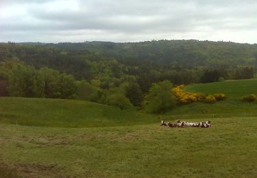
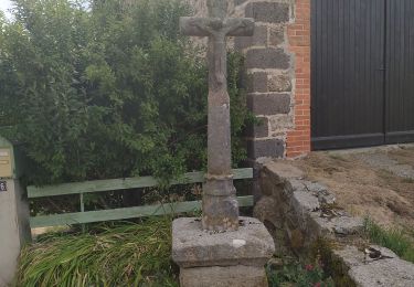
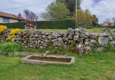
Belle randonnée qui permet de découvrir le petit patrimoine du pays. On y voit de très jolies croix bien restaurées, des lavoirs eux aussi retapés. Nous ne sommes pas descendus jusqu'au Saut du Bezan car le dénivelé nous a fait peur !
 "
data-pinterest-text="Pin it"
data-tweet-text="share on twitter"
data-facebook-share-url="https://www.sitytrail.com/en/trails/3961679-merlexleignec--luriecq-xle-saut-du-bezanx/?photo=1#lg=1&slide=1"
data-twitter-share-url="https://www.sitytrail.com/en/trails/3961679-merlexleignec--luriecq-xle-saut-du-bezanx/?photo=1#lg=1&slide=1"
data-googleplus-share-url="https://www.sitytrail.com/en/trails/3961679-merlexleignec--luriecq-xle-saut-du-bezanx/?photo=1#lg=1&slide=1"
data-pinterest-share-url="https://www.sitytrail.com/en/trails/3961679-merlexleignec--luriecq-xle-saut-du-bezanx/?photo=1#lg=1&slide=1">
"
data-pinterest-text="Pin it"
data-tweet-text="share on twitter"
data-facebook-share-url="https://www.sitytrail.com/en/trails/3961679-merlexleignec--luriecq-xle-saut-du-bezanx/?photo=1#lg=1&slide=1"
data-twitter-share-url="https://www.sitytrail.com/en/trails/3961679-merlexleignec--luriecq-xle-saut-du-bezanx/?photo=1#lg=1&slide=1"
data-googleplus-share-url="https://www.sitytrail.com/en/trails/3961679-merlexleignec--luriecq-xle-saut-du-bezanx/?photo=1#lg=1&slide=1"
data-pinterest-share-url="https://www.sitytrail.com/en/trails/3961679-merlexleignec--luriecq-xle-saut-du-bezanx/?photo=1#lg=1&slide=1">
 "
data-pinterest-text="Pin it"
data-tweet-text="share on twitter"
data-facebook-share-url="https://www.sitytrail.com/en/trails/3961679-merlexleignec--luriecq-xle-saut-du-bezanx/?photo=2#lg=1&slide=2"
data-twitter-share-url="https://www.sitytrail.com/en/trails/3961679-merlexleignec--luriecq-xle-saut-du-bezanx/?photo=2#lg=1&slide=2"
data-googleplus-share-url="https://www.sitytrail.com/en/trails/3961679-merlexleignec--luriecq-xle-saut-du-bezanx/?photo=2#lg=1&slide=2"
data-pinterest-share-url="https://www.sitytrail.com/en/trails/3961679-merlexleignec--luriecq-xle-saut-du-bezanx/?photo=2#lg=1&slide=2">
"
data-pinterest-text="Pin it"
data-tweet-text="share on twitter"
data-facebook-share-url="https://www.sitytrail.com/en/trails/3961679-merlexleignec--luriecq-xle-saut-du-bezanx/?photo=2#lg=1&slide=2"
data-twitter-share-url="https://www.sitytrail.com/en/trails/3961679-merlexleignec--luriecq-xle-saut-du-bezanx/?photo=2#lg=1&slide=2"
data-googleplus-share-url="https://www.sitytrail.com/en/trails/3961679-merlexleignec--luriecq-xle-saut-du-bezanx/?photo=2#lg=1&slide=2"
data-pinterest-share-url="https://www.sitytrail.com/en/trails/3961679-merlexleignec--luriecq-xle-saut-du-bezanx/?photo=2#lg=1&slide=2">
 "
data-pinterest-text="Pin it"
data-tweet-text="share on twitter"
data-facebook-share-url="https://www.sitytrail.com/en/trails/3961679-merlexleignec--luriecq-xle-saut-du-bezanx/?photo=3#lg=1&slide=3"
data-twitter-share-url="https://www.sitytrail.com/en/trails/3961679-merlexleignec--luriecq-xle-saut-du-bezanx/?photo=3#lg=1&slide=3"
data-googleplus-share-url="https://www.sitytrail.com/en/trails/3961679-merlexleignec--luriecq-xle-saut-du-bezanx/?photo=3#lg=1&slide=3"
data-pinterest-share-url="https://www.sitytrail.com/en/trails/3961679-merlexleignec--luriecq-xle-saut-du-bezanx/?photo=3#lg=1&slide=3">
"
data-pinterest-text="Pin it"
data-tweet-text="share on twitter"
data-facebook-share-url="https://www.sitytrail.com/en/trails/3961679-merlexleignec--luriecq-xle-saut-du-bezanx/?photo=3#lg=1&slide=3"
data-twitter-share-url="https://www.sitytrail.com/en/trails/3961679-merlexleignec--luriecq-xle-saut-du-bezanx/?photo=3#lg=1&slide=3"
data-googleplus-share-url="https://www.sitytrail.com/en/trails/3961679-merlexleignec--luriecq-xle-saut-du-bezanx/?photo=3#lg=1&slide=3"
data-pinterest-share-url="https://www.sitytrail.com/en/trails/3961679-merlexleignec--luriecq-xle-saut-du-bezanx/?photo=3#lg=1&slide=3">
 "
data-pinterest-text="Pin it"
data-tweet-text="share on twitter"
data-facebook-share-url="https://www.sitytrail.com/en/trails/3961679-merlexleignec--luriecq-xle-saut-du-bezanx/?photo=4#lg=1&slide=4"
data-twitter-share-url="https://www.sitytrail.com/en/trails/3961679-merlexleignec--luriecq-xle-saut-du-bezanx/?photo=4#lg=1&slide=4"
data-googleplus-share-url="https://www.sitytrail.com/en/trails/3961679-merlexleignec--luriecq-xle-saut-du-bezanx/?photo=4#lg=1&slide=4"
data-pinterest-share-url="https://www.sitytrail.com/en/trails/3961679-merlexleignec--luriecq-xle-saut-du-bezanx/?photo=4#lg=1&slide=4">
"
data-pinterest-text="Pin it"
data-tweet-text="share on twitter"
data-facebook-share-url="https://www.sitytrail.com/en/trails/3961679-merlexleignec--luriecq-xle-saut-du-bezanx/?photo=4#lg=1&slide=4"
data-twitter-share-url="https://www.sitytrail.com/en/trails/3961679-merlexleignec--luriecq-xle-saut-du-bezanx/?photo=4#lg=1&slide=4"
data-googleplus-share-url="https://www.sitytrail.com/en/trails/3961679-merlexleignec--luriecq-xle-saut-du-bezanx/?photo=4#lg=1&slide=4"
data-pinterest-share-url="https://www.sitytrail.com/en/trails/3961679-merlexleignec--luriecq-xle-saut-du-bezanx/?photo=4#lg=1&slide=4">
 "
data-pinterest-text="Pin it"
data-tweet-text="share on twitter"
data-facebook-share-url="https://www.sitytrail.com/en/trails/3961679-merlexleignec--luriecq-xle-saut-du-bezanx/?photo=5#lg=1&slide=5"
data-twitter-share-url="https://www.sitytrail.com/en/trails/3961679-merlexleignec--luriecq-xle-saut-du-bezanx/?photo=5#lg=1&slide=5"
data-googleplus-share-url="https://www.sitytrail.com/en/trails/3961679-merlexleignec--luriecq-xle-saut-du-bezanx/?photo=5#lg=1&slide=5"
data-pinterest-share-url="https://www.sitytrail.com/en/trails/3961679-merlexleignec--luriecq-xle-saut-du-bezanx/?photo=5#lg=1&slide=5">
"
data-pinterest-text="Pin it"
data-tweet-text="share on twitter"
data-facebook-share-url="https://www.sitytrail.com/en/trails/3961679-merlexleignec--luriecq-xle-saut-du-bezanx/?photo=5#lg=1&slide=5"
data-twitter-share-url="https://www.sitytrail.com/en/trails/3961679-merlexleignec--luriecq-xle-saut-du-bezanx/?photo=5#lg=1&slide=5"
data-googleplus-share-url="https://www.sitytrail.com/en/trails/3961679-merlexleignec--luriecq-xle-saut-du-bezanx/?photo=5#lg=1&slide=5"
data-pinterest-share-url="https://www.sitytrail.com/en/trails/3961679-merlexleignec--luriecq-xle-saut-du-bezanx/?photo=5#lg=1&slide=5">
 "
data-pinterest-text="Pin it"
data-tweet-text="share on twitter"
data-facebook-share-url="https://www.sitytrail.com/en/trails/3961679-merlexleignec--luriecq-xle-saut-du-bezanx/?photo=6#lg=1&slide=6"
data-twitter-share-url="https://www.sitytrail.com/en/trails/3961679-merlexleignec--luriecq-xle-saut-du-bezanx/?photo=6#lg=1&slide=6"
data-googleplus-share-url="https://www.sitytrail.com/en/trails/3961679-merlexleignec--luriecq-xle-saut-du-bezanx/?photo=6#lg=1&slide=6"
data-pinterest-share-url="https://www.sitytrail.com/en/trails/3961679-merlexleignec--luriecq-xle-saut-du-bezanx/?photo=6#lg=1&slide=6">
"
data-pinterest-text="Pin it"
data-tweet-text="share on twitter"
data-facebook-share-url="https://www.sitytrail.com/en/trails/3961679-merlexleignec--luriecq-xle-saut-du-bezanx/?photo=6#lg=1&slide=6"
data-twitter-share-url="https://www.sitytrail.com/en/trails/3961679-merlexleignec--luriecq-xle-saut-du-bezanx/?photo=6#lg=1&slide=6"
data-googleplus-share-url="https://www.sitytrail.com/en/trails/3961679-merlexleignec--luriecq-xle-saut-du-bezanx/?photo=6#lg=1&slide=6"
data-pinterest-share-url="https://www.sitytrail.com/en/trails/3961679-merlexleignec--luriecq-xle-saut-du-bezanx/?photo=6#lg=1&slide=6">
 "
data-pinterest-text="Pin it"
data-tweet-text="share on twitter"
data-facebook-share-url="https://www.sitytrail.com/en/trails/3961679-merlexleignec--luriecq-xle-saut-du-bezanx/?photo=7#lg=1&slide=7"
data-twitter-share-url="https://www.sitytrail.com/en/trails/3961679-merlexleignec--luriecq-xle-saut-du-bezanx/?photo=7#lg=1&slide=7"
data-googleplus-share-url="https://www.sitytrail.com/en/trails/3961679-merlexleignec--luriecq-xle-saut-du-bezanx/?photo=7#lg=1&slide=7"
data-pinterest-share-url="https://www.sitytrail.com/en/trails/3961679-merlexleignec--luriecq-xle-saut-du-bezanx/?photo=7#lg=1&slide=7">
"
data-pinterest-text="Pin it"
data-tweet-text="share on twitter"
data-facebook-share-url="https://www.sitytrail.com/en/trails/3961679-merlexleignec--luriecq-xle-saut-du-bezanx/?photo=7#lg=1&slide=7"
data-twitter-share-url="https://www.sitytrail.com/en/trails/3961679-merlexleignec--luriecq-xle-saut-du-bezanx/?photo=7#lg=1&slide=7"
data-googleplus-share-url="https://www.sitytrail.com/en/trails/3961679-merlexleignec--luriecq-xle-saut-du-bezanx/?photo=7#lg=1&slide=7"
data-pinterest-share-url="https://www.sitytrail.com/en/trails/3961679-merlexleignec--luriecq-xle-saut-du-bezanx/?photo=7#lg=1&slide=7">
 "
data-pinterest-text="Pin it"
data-tweet-text="share on twitter"
data-facebook-share-url="https://www.sitytrail.com/en/trails/3961679-merlexleignec--luriecq-xle-saut-du-bezanx/?photo=8#lg=1&slide=8"
data-twitter-share-url="https://www.sitytrail.com/en/trails/3961679-merlexleignec--luriecq-xle-saut-du-bezanx/?photo=8#lg=1&slide=8"
data-googleplus-share-url="https://www.sitytrail.com/en/trails/3961679-merlexleignec--luriecq-xle-saut-du-bezanx/?photo=8#lg=1&slide=8"
data-pinterest-share-url="https://www.sitytrail.com/en/trails/3961679-merlexleignec--luriecq-xle-saut-du-bezanx/?photo=8#lg=1&slide=8">
"
data-pinterest-text="Pin it"
data-tweet-text="share on twitter"
data-facebook-share-url="https://www.sitytrail.com/en/trails/3961679-merlexleignec--luriecq-xle-saut-du-bezanx/?photo=8#lg=1&slide=8"
data-twitter-share-url="https://www.sitytrail.com/en/trails/3961679-merlexleignec--luriecq-xle-saut-du-bezanx/?photo=8#lg=1&slide=8"
data-googleplus-share-url="https://www.sitytrail.com/en/trails/3961679-merlexleignec--luriecq-xle-saut-du-bezanx/?photo=8#lg=1&slide=8"
data-pinterest-share-url="https://www.sitytrail.com/en/trails/3961679-merlexleignec--luriecq-xle-saut-du-bezanx/?photo=8#lg=1&slide=8">
 "
data-pinterest-text="Pin it"
data-tweet-text="share on twitter"
data-facebook-share-url="https://www.sitytrail.com/en/trails/3961679-merlexleignec--luriecq-xle-saut-du-bezanx/?photo=9#lg=1&slide=9"
data-twitter-share-url="https://www.sitytrail.com/en/trails/3961679-merlexleignec--luriecq-xle-saut-du-bezanx/?photo=9#lg=1&slide=9"
data-googleplus-share-url="https://www.sitytrail.com/en/trails/3961679-merlexleignec--luriecq-xle-saut-du-bezanx/?photo=9#lg=1&slide=9"
data-pinterest-share-url="https://www.sitytrail.com/en/trails/3961679-merlexleignec--luriecq-xle-saut-du-bezanx/?photo=9#lg=1&slide=9">
"
data-pinterest-text="Pin it"
data-tweet-text="share on twitter"
data-facebook-share-url="https://www.sitytrail.com/en/trails/3961679-merlexleignec--luriecq-xle-saut-du-bezanx/?photo=9#lg=1&slide=9"
data-twitter-share-url="https://www.sitytrail.com/en/trails/3961679-merlexleignec--luriecq-xle-saut-du-bezanx/?photo=9#lg=1&slide=9"
data-googleplus-share-url="https://www.sitytrail.com/en/trails/3961679-merlexleignec--luriecq-xle-saut-du-bezanx/?photo=9#lg=1&slide=9"
data-pinterest-share-url="https://www.sitytrail.com/en/trails/3961679-merlexleignec--luriecq-xle-saut-du-bezanx/?photo=9#lg=1&slide=9">
 "
data-pinterest-text="Pin it"
data-tweet-text="share on twitter"
data-facebook-share-url="https://www.sitytrail.com/en/trails/3961679-merlexleignec--luriecq-xle-saut-du-bezanx/?photo=10#lg=1&slide=10"
data-twitter-share-url="https://www.sitytrail.com/en/trails/3961679-merlexleignec--luriecq-xle-saut-du-bezanx/?photo=10#lg=1&slide=10"
data-googleplus-share-url="https://www.sitytrail.com/en/trails/3961679-merlexleignec--luriecq-xle-saut-du-bezanx/?photo=10#lg=1&slide=10"
data-pinterest-share-url="https://www.sitytrail.com/en/trails/3961679-merlexleignec--luriecq-xle-saut-du-bezanx/?photo=10#lg=1&slide=10">
"
data-pinterest-text="Pin it"
data-tweet-text="share on twitter"
data-facebook-share-url="https://www.sitytrail.com/en/trails/3961679-merlexleignec--luriecq-xle-saut-du-bezanx/?photo=10#lg=1&slide=10"
data-twitter-share-url="https://www.sitytrail.com/en/trails/3961679-merlexleignec--luriecq-xle-saut-du-bezanx/?photo=10#lg=1&slide=10"
data-googleplus-share-url="https://www.sitytrail.com/en/trails/3961679-merlexleignec--luriecq-xle-saut-du-bezanx/?photo=10#lg=1&slide=10"
data-pinterest-share-url="https://www.sitytrail.com/en/trails/3961679-merlexleignec--luriecq-xle-saut-du-bezanx/?photo=10#lg=1&slide=10">


Walking

Mountain bike
Walking
Walking
Walking
Walking
Walking
Walking
Walking