


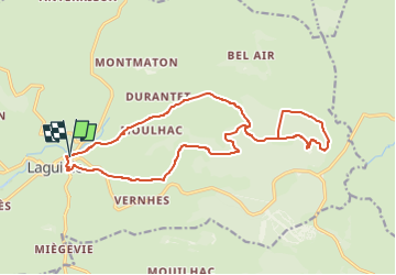
Laguiole 1 - 2024

zot
User

Length
18.6 km

Max alt
1339 m

Uphill gradient
397 m
Km-Effort
24 km

Min alt
986 m

Downhill gradient
397 m
Boucle
Yes
Creation date :
2024-02-25 18:19:41.0
Updated on :
2024-02-25 18:19:42.856
5h25
Difficulty : Very difficult

FREE GPS app for hiking
 SityTrail
IGN / Geographical institutes
SityTrail Plus
The world is yours!
About
Trail Walking of 18.6 km to be discovered at Occitania, Aveyron, Laguiole. This trail is proposed by zot.
Positioning
Country:
France
Region :
Occitania
Department/Province :
Aveyron
Municipality :
Laguiole
Location:
Unknown
Start:(Dec)
Start:(UTM)
488257 ; 4948137 (31T) N.
Comments