


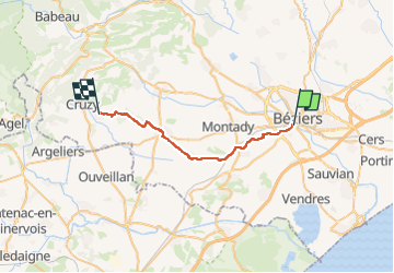
1604 Beziers Quarante

MERMOZ33
User

Length
26 km

Max alt
125 m

Uphill gradient
347 m
Km-Effort
31 km

Min alt
3 m

Downhill gradient
250 m
Boucle
No
Creation date :
2024-02-26 10:12:58.633
Updated on :
2024-03-19 12:58:13.023
6h56
Difficulty : Very difficult

FREE GPS app for hiking
 SityTrail
IGN / Geographical institutes
SityTrail Plus
The world is yours!
About
Trail Walking of 26 km to be discovered at Occitania, Hérault, Béziers. This trail is proposed by MERMOZ33.
Positioning
Country:
France
Region :
Occitania
Department/Province :
Hérault
Municipality :
Béziers
Location:
Unknown
Start:(Dec)
Start:(UTM)
516876 ; 4798164 (31T) N.
Comments