


2024-02-26_15h59m30_ecotrail-de-paris-80-kms

lbuteux
User
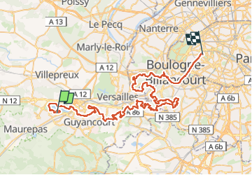

Length
79 km

Max alt
188 m

Uphill gradient
1497 m
Km-Effort
99 km

Min alt
12 m

Downhill gradient
1583 m
Boucle
No
Creation date :
2024-02-26 14:59:30.361
Updated on :
2024-02-26 14:59:32.358

FREE GPS app for hiking
 SityTrail
IGN / Geographical institutes
SityTrail Plus
The world is yours!
About
Trail of 79 km to be discovered at Ile-de-France, Yvelines, Trappes. This trail is proposed by lbuteux.
Description
EcoTrail de Paris 80 kms
Positioning
Country:
France
Region :
Ile-de-France
Department/Province :
Yvelines
Municipality :
Trappes
Location:
Unknown
Start:(Dec)
Start:(UTM)
427182 ; 5403775 (31U) N.
Comments