


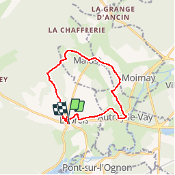
le prieuré de Marast et le Lauzin

nicolasdresse
User

Length
11.5 km

Max alt
347 m

Uphill gradient
185 m
Km-Effort
13.9 km

Min alt
258 m

Downhill gradient
187 m
Boucle
Yes
Creation date :
2018-09-29 20:52:33.72
Updated on :
2018-09-29 20:52:33.739
2h57
Difficulty : Medium

FREE GPS app for hiking
 SityTrail
IGN / Geographical institutes
SityTrail Plus
The world is yours!
About
Trail Walking of 11.5 km to be discovered at Bourgogne-Franche-Comté, Haute-Saône, Esprels. This trail is proposed by nicolasdresse.
Description
Départ de la mairie d esprels à 20 km au sud est de vesoul par la D9.
Positioning
Country:
France
Region :
Bourgogne-Franche-Comté
Department/Province :
Haute-Saône
Municipality :
Esprels
Location:
Unknown
Start:(Dec)
Start:(UTM)
302266 ; 5268150 (32T) N.
Comments