


![Trail On foot Grasse - t200485179_[06] circuit de magagnosc - Photo](https://media.geolcdn.com/t/1900/400/ext.pjpeg?maxdim=2&url=https%3A%2F%2Fstatic1.geolcdn.com%2Fsiteimages%2Fupload%2Ffiles%2F1545311037marcheuse_200dpi.jpg)
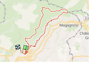
t200485179_[06] circuit de magagnosc

Renefrt
User

Length
12.5 km

Max alt
687 m

Uphill gradient
426 m
Km-Effort
18.1 km

Min alt
420 m

Downhill gradient
426 m
Boucle
Yes
Creation date :
2024-02-26 22:51:37.0
Updated on :
2024-02-27 16:54:44.564
4h07
Difficulty : Easy

FREE GPS app for hiking
 SityTrail
IGN / Geographical institutes
SityTrail Plus
The world is yours!
About
Trail On foot of 12.5 km to be discovered at Provence-Alpes-Côte d'Azur, Maritime Alps, Grasse. This trail is proposed by Renefrt.
Positioning
Country:
France
Region :
Provence-Alpes-Côte d'Azur
Department/Province :
Maritime Alps
Municipality :
Grasse
Location:
Unknown
Start:(Dec)
Start:(UTM)
332970 ; 4836853 (32T) N.
Comments