


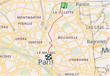
Bassin de La Villette → Bastille

dodef
User

Length
6.1 km

Max alt
59 m

Uphill gradient
56 m
Km-Effort
6.9 km

Min alt
31 m

Downhill gradient
75 m
Boucle
No
Creation date :
2024-02-27 00:41:35.326
Updated on :
2024-03-13 00:11:24.979
1h34
Difficulty : Medium

FREE GPS app for hiking
 SityTrail
IGN / Geographical institutes
SityTrail Plus
The world is yours!
About
Trail Walking of 6.1 km to be discovered at Ile-de-France, Paris, Paris. This trail is proposed by dodef.
Positioning
Country:
France
Region :
Ile-de-France
Department/Province :
Paris
Municipality :
Paris
Location:
19th Arrondissement
Start:(Dec)
Start:(UTM)
454296 ; 5415483 (31U) N.
Comments