


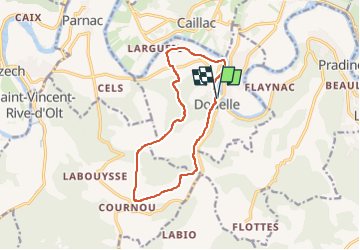
46-Douelle - Cournou

houbart
User

Length
12.6 km

Max alt
300 m

Uphill gradient
233 m
Km-Effort
15.7 km

Min alt
104 m

Downhill gradient
234 m
Boucle
Yes
Creation date :
2024-02-27 09:29:46.677
Updated on :
2024-02-27 09:30:29.288
3h33
Difficulty : Difficult

FREE GPS app for hiking
 SityTrail
IGN / Geographical institutes
SityTrail Plus
The world is yours!
About
Trail Walking of 12.6 km to be discovered at Occitania, Lot, Douelle. This trail is proposed by houbart.
Description
Rando au départ de Douelle et qui monte vers les vignes des environs de Cournou. Le retour se fait par les ruines du village abandonné de Mader
Positioning
Country:
France
Region :
Occitania
Department/Province :
Lot
Municipality :
Douelle
Location:
Unknown
Start:(Dec)
Start:(UTM)
369603 ; 4925497 (31T) N.
Comments