


Nesles-la-Montagne du 27-02-2024

VANDERPUTTENMi
User GUIDE
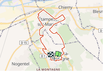

Length
8.1 km

Max alt
191 m

Uphill gradient
168 m
Km-Effort
10.3 km

Min alt
58 m

Downhill gradient
164 m
Boucle
Yes
Creation date :
2024-02-27 12:50:17.969
Updated on :
2024-02-29 18:36:53.975
2h20
Difficulty : Medium

FREE GPS app for hiking
 SityTrail
IGN / Geographical institutes
SityTrail Plus
The world is yours!
About
Trail Walking of 8.1 km to be discovered at Hauts-de-France, Aisne, Nesles-la-Montagne. This trail is proposed by VANDERPUTTENMi.
Photos

Positioning
Country:
France
Region :
Hauts-de-France
Department/Province :
Aisne
Municipality :
Nesles-la-Montagne
Location:
Unknown
Start:(Dec)
Start:(UTM)
530974 ; 5429610 (31U) N.
Comments