


Les 4 Villages

Fky78
User
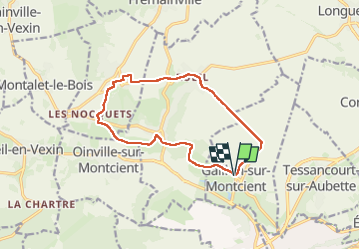

Length
11.8 km

Max alt
127 m

Uphill gradient
236 m
Km-Effort
15 km

Min alt
37 m

Downhill gradient
242 m
Boucle
Yes
Creation date :
2024-02-28 12:30:03.693
Updated on :
2024-03-04 10:24:07.833
3h15
Difficulty : Easy

FREE GPS app for hiking
 SityTrail
IGN / Geographical institutes
SityTrail Plus
The world is yours!
About
Trail Walking of 11.8 km to be discovered at Ile-de-France, Yvelines, Gaillon-sur-Montcient. This trail is proposed by Fky78.
Description
Stationnement parking de la mairie,
balade vallonnée sans difficulté pas trop de gadoue par temps humide sauf un passage
Positioning
Country:
France
Region :
Ile-de-France
Department/Province :
Yvelines
Municipality :
Gaillon-sur-Montcient
Location:
Unknown
Start:(Dec)
Start:(UTM)
418989 ; 5430863 (31U) N.
Comments