Trail Walking Gaillon-sur-Montcient - Les 4 Villages - Photo
 Fky78
Fky78

User

© OpenStreetMap contributors
Length
Length
11.8 km
Max alt
Max alt
127 m
Uphill gradient
Uphill gradient
236 m
Km-Effort
Km-Effort  
15 km
Min alt
Min alt
37 m
Downhill gradient
Downhill gradient
242 m
Boucle
Boucle
Yes
Creation date :
2024-02-28 12:30:03.693
Updated on :
2024-03-04 10:24:07.833

(0 Reviews)

Walking
Walking
3h15
Difficulty : Easy

Scan this QR Code to open this trail in the SityTrail application

FREE GPS app for hiking

Logo SityTrail SityTrail

IGN / Geographical institutes

Download SityTrail from the App Store Download SityTrail from Google Play

Logo SityTrail SityTrail World

The world is yours!

Download SityTrail from the App Store Download SityTrail from Google Play Download SityTrail on Huawei AppGallery

About

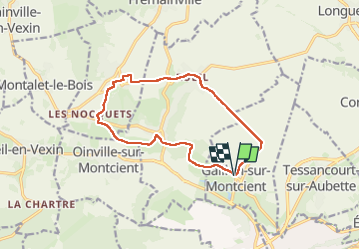
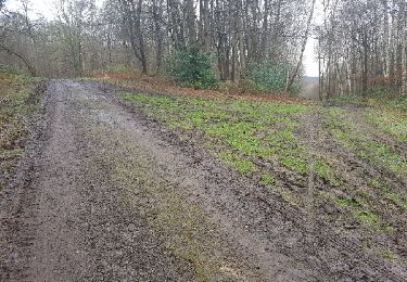
Trail Walking of 11.8 km to be discovered at Ile-de-France, Yvelines, Gaillon-sur-Montcient. This trail is proposed by Fky78.

Description

Stationnement parking de la mairie,
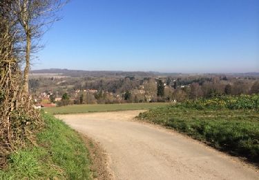
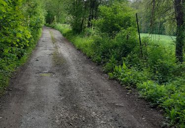
balade vallonnée sans difficulté pas trop de gadoue par temps humide sauf un passage

Elevation profile

Positioning

Country:
France
Region :
Ile-de-France
Department/Province :
Yvelines
Municipality :
Gaillon-sur-Montcient
Location:
Unknown
Start:(UTM)
418989 ; 5430863 (31U) N.

Trails nearby

Trail Nordic walking Frémainville - Forêt de Galluis - Photo
Nordic walking
Fky78

Nordic walking

Easy
(1)
Frémainville, Ile-de-France, Val-d'Oise, France
6 km | 7.3 km-effort
1h 20min
Yes
Trail Walking Seraincourt - la cave aux fées  - Photo
Walking
laurentbernardbrunel

Walking

Easy
(2)
Seraincourt, Ile-de-France, Val-d'Oise, France
13 km | 16.1 km-effort
2h 35min
Yes
Trail Walking Oinville-sur-Montcient - Oinville sur Moncient - Photo
Walking
fredouille661

Walking

Very easy
(1)
Oinville-sur-Montcient, Ile-de-France, Yvelines, France
10.9 km | 13.8 km-effort
2h 39min
Yes
Trail Walking Gaillon-sur-Montcient - En passant par Dalibray - Photo
Walking
Fky78

Walking

Difficult
Gaillon-sur-Montcient, Ile-de-France, Yvelines, France
10.1 km | 12.8 km-effort
2h 34min
Yes
Trail On foot Oinville-sur-Montcient - GR2 Accès - Photo
On foot
PRO

On foot

Easy
Oinville-sur-Montcient, Ile-de-France, Yvelines, France
4.3 km | 4.9 km-effort
1h 6min
No
Trail Walking Seraincourt - Rueil-Seraincourt RDA 01 - Photo
Walking
dufland

Walking

Medium
(1)
Seraincourt, Ile-de-France, Val-d'Oise, France
15.4 km | 17.3 km-effort
3h 50min
Yes
Trail Walking Verneuil-sur-Seine - les clairieres de Verneuil - Photo
Walking
mimey

Walking

Difficult
Verneuil-sur-Seine, Ile-de-France, Yvelines, France
31 km | 38 km-effort
5h 55min
No
Trail Walking Jambville - jambville - Photo
Walking
randouille

Walking

Easy
Jambville, Ile-de-France, Yvelines, France
15.4 km | 0 m-effort
7h 30min
Yes
Trail Running Frémainville - Canicross fremainville 5km - Photo
Running
unirega

Running

Difficult
Frémainville, Ile-de-France, Val-d'Oise, France
4.9 km | 6.2 km-effort
1h 10min
Yes


Close
My subscriptions