Trail Horseback riding Plainfaing - Circuit Alsace Vosges Fraize Orbey - Photo

Circuit Alsace Vosges Fraize Orbey

Promouvoir le Tourisme Equestre en Alsace GUIDE+

© OpenStreetMap contributors
Length
Length
30 km
Max alt
Max alt
1303 m
Uphill gradient
Uphill gradient
1288 m
Km-Effort
Km-Effort  
46 km
Min alt
Min alt
559 m
Downhill gradient
Downhill gradient
1105 m
Boucle
Boucle
No
Creation date :
2024-02-28 16:42:17.689
Updated on :
2024-02-28 16:48:17.648

(0 Reviews)

Horseback riding
Horseback riding
6h05
Difficulty : Medium

Scan this QR Code to open this trail in the SityTrail application

FREE GPS app for hiking

Logo SityTrail SityTrail

IGN / Geographical institutes

Download SityTrail from the App Store Download SityTrail from Google Play

Logo SityTrail SityTrail World

The world is yours!

Download SityTrail from the App Store Download SityTrail from Google Play Download SityTrail on Huawei AppGallery

About

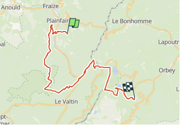
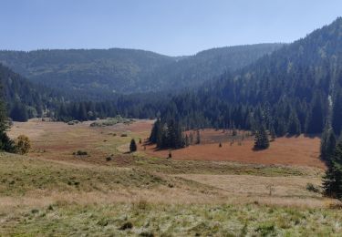
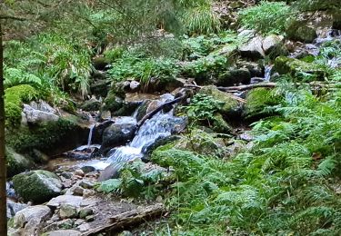
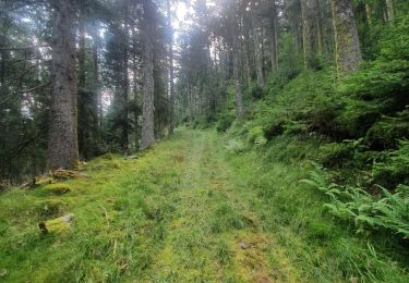
Trail Horseback riding of 30 km to be discovered at Grand Est, Vosges, Plainfaing. This trail is proposed by Tourisme Equestre Alsace.

Description

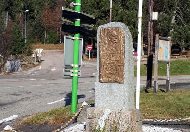
Circuit Entre l’Alsace et les Vosges : Etape entre Fraize et  Orbey

Elevation profile

Photos

Points of interest

Point of interest Plainfaing - Col de Louschbach - Photo
holtzv
PLAINFAING 

Positioning

Country:
France
Region :
Grand Est
Department/Province :
Vosges
Municipality :
Plainfaing
Location:
Unknown
Start:(UTM)
353163 ; 5335977 (32U) N.

Trails nearby

Trail Walking Le Bonhomme - Tête des faux . - Photo
Walking
heurtinpatrick

Walking

Medium
(1)
Le Bonhomme, Grand Est, Haut-Rhin, France
11.9 km | 16.6 km-effort
3h 46min
Yes
Trail Walking Mandray - Chapelle de mangegoutte - Photo
Walking
pida

Walking

Easy
(3)
Mandray, Grand Est, Vosges, France
6.1 km | 9 km-effort
1h 54min
Yes
Trail Walking Le Bonhomme - Lac blanc col du calvaire - Photo
Walking
FOUCAULT

Walking

Le Bonhomme, Grand Est, Haut-Rhin, France
5 km | 7.2 km-effort
2h 13min
Yes
Trail Walking Orbey - 5 lacs  - Photo
Walking
matthieuni

Walking

Very difficult
Orbey, Grand Est, Haut-Rhin, France
24 km | 39 km-effort
5h 43min
No
Trail On foot Orbey - Tour du Lac Blanc - Photo
On foot
PRO

On foot

Easy
Orbey, Grand Est, Haut-Rhin, France
4.7 km | 7.9 km-effort
1h 47min
No
Trail Walking Le Bonhomme - Col du calvaire Bonhomme Lac Blanc - Photo
Walking
oscar1

Walking

Easy
Le Bonhomme, Grand Est, Haut-Rhin, France
15 km | 22 km-effort
3h 9min
Yes
Trail Walking Ban-sur-Meurthe-Clefcy - 2021-10-09 Marche St Die Metzeral Jour 2 - Photo
Walking
GUIDE
holtzv

Walking

Very difficult
Ban-sur-Meurthe-Clefcy, Grand Est, Vosges, France
26 km | 40 km-effort
7h 23min
No
Trail Walking Plainfaing - 20210930_rando_Yol_Roches_de_Valtin - Photo
Walking
nfranche

Walking

Very difficult
Plainfaing, Grand Est, Vosges, France
14.2 km | 24 km-effort
5h 32min
Yes
Trail Walking Fraize - mp fraize 2021 - Photo
Walking
GUIDE
stempfel52

Walking

Very difficult
Fraize, Grand Est, Vosges, France
21 km | 32 km-effort
6h 14min
Yes


Close
My subscriptions