caussols club

clintest
User
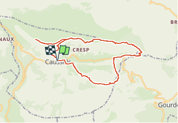

Length
18.9 km

Max alt
1450 m

Uphill gradient
586 m
Km-Effort
27 km

Min alt
1080 m

Downhill gradient
587 m
Boucle
Yes
Creation date :
2024-02-28 20:01:27.852
Updated on :
2024-02-28 20:04:25.876
6h04
Difficulty : Medium

FREE GPS app for hiking
 SityTrail
IGN / Geographical institutes
SityTrail Plus
The world is yours!
About
Trail On foot of 18.9 km to be discovered at Provence-Alpes-Côte d'Azur, Maritime Alps, Caussols. This trail is proposed by clintest.
Positioning
Country:
France
Region :
Provence-Alpes-Côte d'Azur
Department/Province :
Maritime Alps
Municipality :
Caussols
Location:
Unknown
Start:(Dec)
Start:(UTM)
330893 ; 4845308 (32T) N.
Comments