


Rando- Refuge Siou Blanc-Clos de Peyron-Aiguilles de valbelle By Tom
immortelles2020
prendre plaisir à faire plaisir
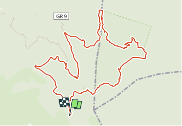

Length
14.4 km

Max alt
720 m

Uphill gradient
406 m
Km-Effort
19.9 km

Min alt
388 m

Downhill gradient
411 m
Boucle
Yes
Creation date :
2024-02-29 06:54:26.049
Updated on :
2024-02-29 06:54:26.049

FREE GPS app for hiking
 SityTrail
IGN / Geographical institutes
SityTrail Plus
The world is yours!
About
Trail of 14.4 km to be discovered at Provence-Alpes-Côte d'Azur, Var, Signes. This trail is proposed by immortelles2020.
Positioning
Country:
France
Region :
Provence-Alpes-Côte d'Azur
Department/Province :
Var
Municipality :
Signes
Location:
Unknown
Start:(Dec)
Start:(UTM)
737199 ; 4790431 (31T) N.
Comments