


Le reydissard

moving
User

Length
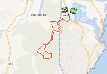
7.7 km

Max alt
190 m

Uphill gradient
238 m
Km-Effort
10.8 km

Min alt
6 m

Downhill gradient
232 m
Boucle
Yes
Creation date :
2024-02-29 07:37:59.213
Updated on :
2024-02-29 10:51:28.577
3h17
Difficulty : Medium

FREE GPS app for hiking
 SityTrail
IGN / Geographical institutes
SityTrail Plus
The world is yours!
About
Trail Walking of 7.7 km to be discovered at Provence-Alpes-Côte d'Azur, Var, Fréjus. This trail is proposed by moving.
Positioning
Country:
France
Region :
Provence-Alpes-Côte d'Azur
Department/Province :
Var
Municipality :
Fréjus
Location:
Unknown
Start:(Dec)
Start:(UTM)
314663 ; 4808113 (32T) N.
Comments