


cayenne

Gmhlt5
User
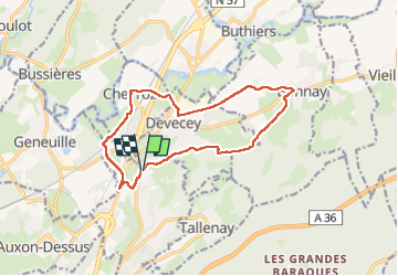

Length
13.1 km

Max alt
288 m

Uphill gradient
189 m
Km-Effort
15.6 km

Min alt
217 m

Downhill gradient
190 m
Boucle
Yes
Creation date :
2024-02-29 07:45:35.367
Updated on :
2024-02-29 11:09:01.494
3h22
Difficulty : Difficult

FREE GPS app for hiking
 SityTrail
IGN / Geographical institutes
SityTrail Plus
The world is yours!
About
Trail Walking of 13.1 km to be discovered at Bourgogne-Franche-Comté, Doubs, Châtillon-le-Duc. This trail is proposed by Gmhlt5.
Description
Marche
Positioning
Country:
France
Region :
Bourgogne-Franche-Comté
Department/Province :
Doubs
Municipality :
Châtillon-le-Duc
Location:
Unknown
Start:(Dec)
Start:(UTM)
273428 ; 5244778 (32T) N.
Comments