


Puyricard - ancien canal du verdon

mhetpierre
User
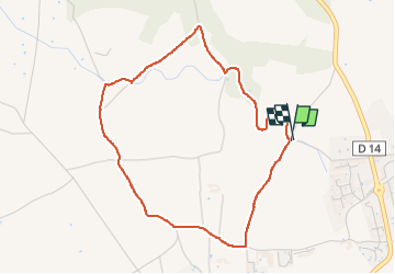

Length
4.5 km

Max alt
349 m

Uphill gradient
65 m
Km-Effort
5.4 km

Min alt
296 m

Downhill gradient
66 m
Boucle
Yes
Creation date :
2024-02-29 13:18:13.0
Updated on :
2024-02-29 16:17:07.408
1h18
Difficulty : Easy

FREE GPS app for hiking
 SityTrail
IGN / Geographical institutes
SityTrail Plus
The world is yours!
About
Trail Walking of 4.5 km to be discovered at Provence-Alpes-Côte d'Azur, Bouches-du-Rhône, Aix-en-Provence. This trail is proposed by mhetpierre.
Positioning
Country:
France
Region :
Provence-Alpes-Côte d'Azur
Department/Province :
Bouches-du-Rhône
Municipality :
Aix-en-Provence
Location:
Unknown
Start:(Dec)
Start:(UTM)
695741 ; 4829550 (31T) N.
Comments