


2024-23-07-Cernay

Rando MLC
User
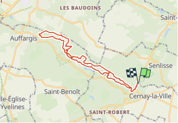

Length
28 km

Max alt
187 m

Uphill gradient
500 m
Km-Effort
34 km

Min alt
112 m

Downhill gradient
500 m
Boucle
Yes
Creation date :
2024-02-29 15:37:39.989
Updated on :
2024-02-29 15:39:07.361
7h50
Difficulty : Very difficult

FREE GPS app for hiking
 SityTrail
IGN / Geographical institutes
SityTrail Plus
The world is yours!
About
Trail Walking of 28 km to be discovered at Ile-de-France, Yvelines, Senlisse. This trail is proposed by Rando MLC.
Positioning
Country:
France
Region :
Ile-de-France
Department/Province :
Yvelines
Municipality :
Senlisse
Location:
Unknown
Start:(Dec)
Start:(UTM)
423901 ; 5392276 (31U) N.
Comments