


venterol

Joel26400
User
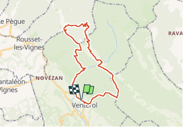

Length
17.5 km

Max alt
868 m

Uphill gradient
898 m
Km-Effort
29 km

Min alt
404 m

Downhill gradient
899 m
Boucle
Yes
Creation date :
2024-02-29 08:35:28.529
Updated on :
2024-02-29 16:13:00.194
5h56
Difficulty : Very difficult

FREE GPS app for hiking
 SityTrail
IGN / Geographical institutes
SityTrail Plus
The world is yours!
About
Trail Walking of 17.5 km to be discovered at Auvergne-Rhône-Alpes, Drôme, Venterol. This trail is proposed by Joel26400.
Description
belle mais technique
Photos

Positioning
Country:
France
Region :
Auvergne-Rhône-Alpes
Department/Province :
Drôme
Municipality :
Venterol
Location:
Unknown
Start:(Dec)
Start:(UTM)
667045 ; 4917435 (31T) N.
Comments