


Blanchard Rando-Santé du 01-03-2024

VANDERPUTTENMi
User GUIDE
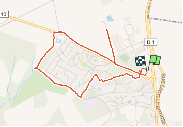

Length
4.9 km

Max alt
219 m

Uphill gradient
42 m
Km-Effort
5.4 km

Min alt
196 m

Downhill gradient
44 m
Boucle
Yes
Creation date :
2024-03-01 12:42:13.09
Updated on :
2024-03-03 18:25:07.908
1h14
Difficulty : Easy

FREE GPS app for hiking
 SityTrail
IGN / Geographical institutes
SityTrail Plus
The world is yours!
About
Trail Walking of 4.9 km to be discovered at Hauts-de-France, Aisne, Château-Thierry. This trail is proposed by VANDERPUTTENMi.
Photos

Positioning
Country:
France
Region :
Hauts-de-France
Department/Province :
Aisne
Municipality :
Château-Thierry
Location:
Unknown
Start:(Dec)
Start:(UTM)
528762 ; 5434438 (31U) N.
Comments