![](/images/other/stat-length.png)
![Trail Nordic walking Heillecourt - Heillecourt 10 750m +93m - Photo](https://media.geolcdn.com/t/1900/400/ext.pjpeg?maxdim=2&url=https%3A%2F%2Fstatic1.geolcdn.com%2Fsiteimages%2Fupload%2Ffiles%2F1545311037marcheuse_200dpi.jpg)
Heillecourt 10 750m +93m
DanielROLLET
User
![Length](/images/other/stat-length.png)
Length
10.7 km
![Max alt](https://static1.geolcdn.com/siteimages/upload/files/1508320355ic_sort_altitude_max_24dp.png)
Max alt
243 m
![Uphill gradient](https://static1.geolcdn.com/siteimages/upload/files/1508320355ic_sort_den_pos_24dp.png)
Uphill gradient
93 m
![Km-Effort](/images/other/stat-length.png)
Km-Effort
12 km
![Min alt](https://static1.geolcdn.com/siteimages/upload/files/1508320355ic_sort_altitude_min_24dp.png)
Min alt
205 m
![Downhill gradient](https://static1.geolcdn.com/siteimages/upload/files/1508320355ic_sort_den_neg_24dp.png)
Downhill gradient
91 m
![Boucle](https://static1.geolcdn.com/siteimages/upload/files/16400158638029165_repeat_loop_refresh_sync_direction_icon.png)
Boucle
Yes
Creation date :
2024-03-02 08:02:07.074
Updated on :
2024-03-02 13:03:42.137
![Nordic walking](https://static1.geolcdn.com/sitytour/trail-icons/102.png)
2h15
Difficulty : Very easy
![Scan this QR Code to open this trail in the SityTrail application](https://capi.geolives.com/qq0zvz2zws4bq2lad0pu/sitytour/trails/3967468/qr.png?size=200)
FREE GPS app for hiking
About
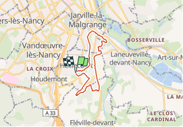
Trail Nordic walking of 10.7 km to be discovered at Grand Est, Meurthe-et-Moselle, Heillecourt. This trail is proposed by DanielROLLET.
Description
2024 03 02 MND avec Rando Pattes 54 - 11 participants
Temps frais et calme
Pause trop longue (17mn!)
arrêts fréquents pour attendre les derniers
Positioning
Country:
France
Region :
Grand Est
Department/Province :
Meurthe-et-Moselle
Municipality :
Heillecourt
Location:
Unknown
Start:(Dec)
Start:(UTM)
293369 ; 5392302 (32U) N.
Comments
Trails nearby
![Trail On foot Fléville-devant-Nancy - Fléville-devant-Nancy et son château - Photo](https://media.geolcdn.com/t/375/260/ext.jpg?maxdim=2&url=https%3A%2F%2Fmedia.geolcdn.com%2Ff%2Fee7686de-cd52-43ca-b6f5-ed4c3a349bb0.jpeg)
![On foot On foot](https://static1.geolcdn.com/sitytour/trail-icons/100.png)
Fléville-devant-Nancy et son château
On foot
Easy
Fléville-devant-Nancy,
Grand Est,
Meurthe-et-Moselle,
France
![](/images/other/stat-length.png)
7.9 km | 9.4 km-effort
2h 8min
![](https://static1.geolcdn.com/siteimages/upload/files/16400158638029165_repeat_loop_refresh_sync_direction_icon.png)
Yes
![Trail Walking Nancy - Ma dernière avant opération - Photo](https://media.geolcdn.com/t/375/260/ext.jpg?maxdim=2&url=https%3A%2F%2Fstatic1.geolcdn.com%2Fsiteimages%2Fupload%2Ffiles%2F1553511878bg_sport_marche.png)
![Walking Walking](https://static1.geolcdn.com/sitytour/trail-icons/101.png)
Ma dernière avant opération
Walking
Very difficult
(1)
Nancy,
Grand Est,
Meurthe-et-Moselle,
France
![](/images/other/stat-length.png)
22 km | 25 km-effort
4h 12min
![](https://static1.geolcdn.com/siteimages/upload/files/16400158638029165_repeat_loop_refresh_sync_direction_icon.png)
Yes
![Trail Walking Vandœuvre-lès-Nancy - Randonnée USEP 2023 - Photo](https://media.geolcdn.com/t/375/260/ext.jpg?maxdim=2&url=https%3A%2F%2Fstatic1.geolcdn.com%2Fsiteimages%2Fupload%2Ffiles%2F1553511878bg_sport_marche.png)
![Walking Walking](https://static1.geolcdn.com/sitytour/trail-icons/101.png)
Randonnée USEP 2023
Walking
Difficult
(1)
Vandœuvre-lès-Nancy,
Grand Est,
Meurthe-et-Moselle,
France
![](/images/other/stat-length.png)
11.7 km | 15.2 km-effort
3h 27min
![](https://static1.geolcdn.com/siteimages/upload/files/16400158638029165_repeat_loop_refresh_sync_direction_icon.png)
No
![Trail Walking Ludres - marche nuit - Photo](https://media.geolcdn.com/t/375/260/ext.jpg?maxdim=2&url=https%3A%2F%2Fmedia.geolcdn.com%2Ff%2F2c15af7e-0536-4068-be2b-216477912337.jpg)
![Walking Walking](https://static1.geolcdn.com/sitytour/trail-icons/101.png)
marche nuit
Walking
Medium
Ludres,
Grand Est,
Meurthe-et-Moselle,
France
![](/images/other/stat-length.png)
8.7 km | 10.1 km-effort
2h 11min
![](https://static1.geolcdn.com/siteimages/upload/files/16400158638029165_repeat_loop_refresh_sync_direction_icon.png)
Yes
![Trail Walking Nancy - Ma rando du jour - Photo](https://media.geolcdn.com/t/375/260/ext.jpg?maxdim=2&url=https%3A%2F%2Fmedia.geolcdn.com%2Ff%2Fc990ad83-2661-43f9-99e0-4498fd5d020a.jpg)
![Walking Walking](https://static1.geolcdn.com/sitytour/trail-icons/101.png)
Ma rando du jour
Walking
Difficult
Nancy,
Grand Est,
Meurthe-et-Moselle,
France
![](/images/other/stat-length.png)
35 km | 41 km-effort
5h 55min
![](https://static1.geolcdn.com/siteimages/upload/files/16400158638029165_repeat_loop_refresh_sync_direction_icon.png)
Yes
![Trail Walking Nancy - Nancy Gondreville Nancy - Photo](https://media.geolcdn.com/t/375/260/ext.jpg?maxdim=2&url=https%3A%2F%2Fmedia.geolcdn.com%2Ff%2F171b4f53-1717-4b2e-9789-6c40dd8e1481.jpg)
![Walking Walking](https://static1.geolcdn.com/sitytour/trail-icons/101.png)
Nancy Gondreville Nancy
Walking
Difficult
Nancy,
Grand Est,
Meurthe-et-Moselle,
France
![](/images/other/stat-length.png)
64 km | 74 km-effort
10h 57min
![](https://static1.geolcdn.com/siteimages/upload/files/16400158638029165_repeat_loop_refresh_sync_direction_icon.png)
Yes
![Trail Walking Nancy - Nancy Saizeray Jaillon Pierre la Treiche Marion Nancy - Photo](https://media.geolcdn.com/t/375/260/ext.jpg?maxdim=2&url=https%3A%2F%2Fmedia.geolcdn.com%2Ff%2F9e40712a-6db3-4fe8-9edd-58851d16cb4f.jpg)
![Walking Walking](https://static1.geolcdn.com/sitytour/trail-icons/101.png)
Nancy Saizeray Jaillon Pierre la Treiche Marion Nancy
Walking
Difficult
Nancy,
Grand Est,
Meurthe-et-Moselle,
France
![](/images/other/stat-length.png)
73 km | 85 km-effort
12h 13min
![](https://static1.geolcdn.com/siteimages/upload/files/16400158638029165_repeat_loop_refresh_sync_direction_icon.png)
Yes
![Trail On foot Villers-lès-Nancy - Promenade d'Hardeval - Photo](https://media.geolcdn.com/t/375/260/ext.jpg?maxdim=2&url=https%3A%2F%2Fmedia.geolcdn.com%2Ff%2F43cb5da8-59dd-45f8-ae11-ca17f70000c7.jpeg)
![On foot On foot](https://static1.geolcdn.com/sitytour/trail-icons/100.png)
Promenade d'Hardeval
On foot
Easy
Villers-lès-Nancy,
Grand Est,
Meurthe-et-Moselle,
France
![](/images/other/stat-length.png)
3.2 km | 4.3 km-effort
58min
![](https://static1.geolcdn.com/siteimages/upload/files/16400158638029165_repeat_loop_refresh_sync_direction_icon.png)
Yes
![Trail Walking Nancy - Nancy - Gondreville - Nancy - Photo](https://media.geolcdn.com/t/375/260/ext.jpg?maxdim=2&url=https%3A%2F%2Fmedia.geolcdn.com%2Ff%2F1ba94617-550e-4800-a823-8e357aef3619.jpg)
![Walking Walking](https://static1.geolcdn.com/sitytour/trail-icons/101.png)
Nancy - Gondreville - Nancy
Walking
Medium
Nancy,
Grand Est,
Meurthe-et-Moselle,
France
![](/images/other/stat-length.png)
64 km | 74 km-effort
24h 59min
![](https://static1.geolcdn.com/siteimages/upload/files/16400158638029165_repeat_loop_refresh_sync_direction_icon.png)
Yes