


Cesson Sévigné 02/02/24

ericbou
User
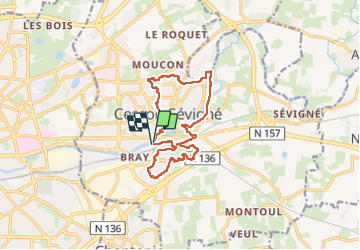

Length
13.2 km

Max alt
57 m

Uphill gradient
110 m
Km-Effort
14.6 km

Min alt
25 m

Downhill gradient
109 m
Boucle
Yes
Creation date :
2024-03-02 12:59:54.89
Updated on :
2024-03-02 16:35:23.164
3h35
Difficulty : Difficult

FREE GPS app for hiking
 SityTrail
IGN / Geographical institutes
SityTrail Plus
The world is yours!
About
Trail Walking of 13.2 km to be discovered at Brittany, Ille-et-Vilaine, Cesson-Sévigné. This trail is proposed by ericbou.
Positioning
Country:
France
Region :
Brittany
Department/Province :
Ille-et-Vilaine
Municipality :
Cesson-Sévigné
Location:
Unknown
Start:(Dec)
Start:(UTM)
603540 ; 5329824 (30U) N.
Comments