


arche du mont aurelien

frederic bruguier
User
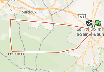

Length
19.9 km

Max alt
853 m

Uphill gradient
1163 m
Km-Effort
35 km

Min alt
286 m

Downhill gradient
1162 m
Boucle
Yes
Creation date :
2024-03-03 07:47:59.766
Updated on :
2024-03-03 08:04:49.01
8h02
Difficulty : Very difficult

FREE GPS app for hiking
 SityTrail
IGN / Geographical institutes
SityTrail Plus
The world is yours!
About
Trail Walking of 19.9 km to be discovered at Provence-Alpes-Côte d'Azur, Var, Saint-Maximin-la-Sainte-Baume. This trail is proposed by frederic bruguier.
Description
a la rercherche du mont aurelien
Positioning
Country:
France
Region :
Provence-Alpes-Côte d'Azur
Department/Province :
Var
Municipality :
Saint-Maximin-la-Sainte-Baume
Location:
Unknown
Start:(Dec)
Start:(UTM)
731798 ; 4815232 (31T) N.
Comments