Oberbronn Weisse Birke Immenkopf

maureengeorges
User
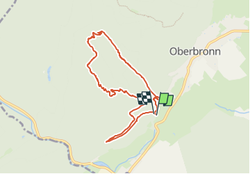

Length
7.8 km

Max alt
495 m

Uphill gradient
305 m
Km-Effort
11.8 km

Min alt
244 m

Downhill gradient
300 m
Boucle
Yes
Creation date :
2024-03-03 08:16:47.705
Updated on :
2024-03-03 08:16:49.537
2h41
Difficulty : Medium

FREE GPS app for hiking
 SityTrail
IGN / Geographical institutes
SityTrail Plus
The world is yours!
About
Trail Walking of 7.8 km to be discovered at Grand Est, Bas-Rhin, Oberbronn. This trail is proposed by maureengeorges.
Positioning
Country:
France
Region :
Grand Est
Department/Province :
Bas-Rhin
Municipality :
Oberbronn
Location:
Unknown
Start:(Dec)
Start:(UTM)
397376 ; 5420825 (32U) N.
Comments