


BOUCLE MONTIPEZE - LE CHALET - MONTIPEZE

Combaut11
User
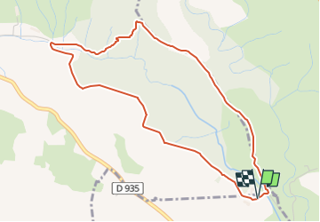

Length
5.1 km

Max alt
214 m

Uphill gradient
102 m
Km-Effort
6.5 km

Min alt
146 m

Downhill gradient
104 m
Boucle
Yes
Creation date :
2024-03-03 13:24:28.815
Updated on :
2024-03-14 16:23:07.456
1h28
Difficulty : Medium

FREE GPS app for hiking
 SityTrail
IGN / Geographical institutes
SityTrail Plus
The world is yours!
About
Trail Walking of 5.1 km to be discovered at Occitania, Aude, Villegailhenc. This trail is proposed by Combaut11.
Positioning
Country:
France
Region :
Occitania
Department/Province :
Aude
Municipality :
Villegailhenc
Location:
Unknown
Start:(Dec)
Start:(UTM)
447152 ; 4792475 (31T) N.
Comments