


rando huitre 2

evelyne10
User
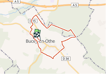

Length
7.1 km

Max alt
240 m

Uphill gradient
147 m
Km-Effort
9.1 km

Min alt
141 m

Downhill gradient
151 m
Boucle
No
Creation date :
2024-03-04 13:19:03.791
Updated on :
2024-03-04 15:14:10.745
1h54
Difficulty : Very easy

FREE GPS app for hiking
 SityTrail
IGN / Geographical institutes
SityTrail Plus
The world is yours!
About
Trail Walking of 7.1 km to be discovered at Grand Est, Aube, Bucey-en-Othe. This trail is proposed by evelyne10.
Positioning
Country:
France
Region :
Grand Est
Department/Province :
Aube
Municipality :
Bucey-en-Othe
Location:
Unknown
Start:(Dec)
Start:(UTM)
563838 ; 5345576 (31U) N.
Comments