


Giverny Promenade version inondation

Fky78
User
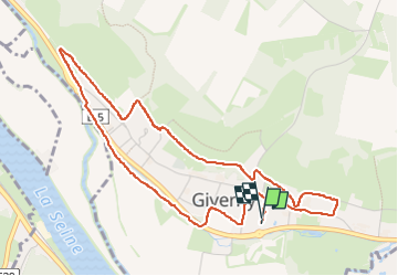

Length
5.1 km

Max alt
56 m

Uphill gradient
60 m
Km-Effort
5.9 km

Min alt
13 m

Downhill gradient
59 m
Boucle
Yes
Creation date :
2024-03-04 13:32:48.376
Updated on :
2024-03-04 15:23:46.241
1h30
Difficulty : Easy

FREE GPS app for hiking
 SityTrail
IGN / Geographical institutes
SityTrail Plus
The world is yours!
About
Trail Walking of 5.1 km to be discovered at Normandy, Eure, Giverny. This trail is proposed by Fky78.
Description
si pas inondé possibilité passer par gd parking sur la fin
Positioning
Country:
France
Region :
Normandy
Department/Province :
Eure
Municipality :
Giverny
Location:
Unknown
Start:(Dec)
Start:(UTM)
392644 ; 5436820 (31U) N.
Comments