


Tannières du 04-03-2024

VANDERPUTTENMi
User GUIDE
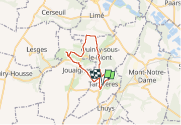

Length
10.6 km

Max alt
134 m

Uphill gradient
179 m
Km-Effort
13 km

Min alt
71 m

Downhill gradient
176 m
Boucle
Yes
Creation date :
2024-03-04 10:36:21.968
Updated on :
2024-03-04 17:42:35.747
2h56
Difficulty : Difficult

FREE GPS app for hiking
 SityTrail
IGN / Geographical institutes
SityTrail Plus
The world is yours!
About
Trail Walking of 10.6 km to be discovered at Hauts-de-France, Aisne, Tannières. This trail is proposed by VANDERPUTTENMi.
Photos


Positioning
Country:
France
Region :
Hauts-de-France
Department/Province :
Aisne
Municipality :
Tannières
Location:
Unknown
Start:(Dec)
Start:(UTM)
540199 ; 5459938 (31U) N.
Comments