


Lacs de Consaterre

frizou83
User
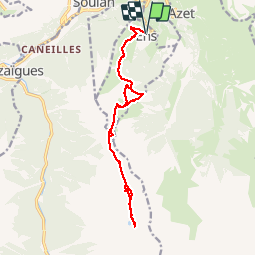

Length
16.5 km

Max alt
2360 m

Uphill gradient
1326 m
Km-Effort
34 km

Min alt
1207 m

Downhill gradient
1325 m
Boucle
Yes
Creation date :
2015-03-17 00:00:00.0
Updated on :
2015-03-17 00:00:00.0
6h56
Difficulty : Difficult

FREE GPS app for hiking
 SityTrail
IGN / Geographical institutes
SityTrail Plus
The world is yours!
About
Trail Walking of 16.5 km to be discovered at Occitania, Hautespyrenees, Ens. This trail is proposed by frizou83.
Positioning
Country:
France
Region :
Occitania
Department/Province :
Hautespyrenees
Municipality :
Ens
Location:
Unknown
Start:(Dec)
Start:(UTM)
282520 ; 4742802 (31T) N.
Comments