


Puechredon

JMJ42
User
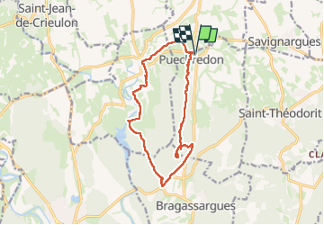

Length
14.7 km

Max alt
227 m

Uphill gradient
245 m
Km-Effort
18 km

Min alt
79 m

Downhill gradient
243 m
Boucle
Yes
Creation date :
2024-03-05 08:28:44.743
Updated on :
2024-03-05 14:20:15.382
5h09
Difficulty : Easy

FREE GPS app for hiking
 SityTrail
IGN / Geographical institutes
SityTrail Plus
The world is yours!
About
Trail Walking of 14.7 km to be discovered at Occitania, Gard, Puechredon. This trail is proposed by JMJ42.
Positioning
Country:
France
Region :
Occitania
Department/Province :
Gard
Municipality :
Puechredon
Location:
Unknown
Start:(Dec)
Start:(UTM)
584214 ; 4867791 (31T) N.
Comments