


la Dôle par la Cabosse

cron
User
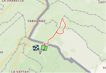

Length
10.2 km

Max alt
1669 m

Uphill gradient
559 m
Km-Effort
17.7 km

Min alt
1379 m

Downhill gradient
559 m
Boucle
Yes
Creation date :
2024-03-06 10:50:14.708
Updated on :
2024-03-06 10:51:37.565
4h00
Difficulty : Difficult

FREE GPS app for hiking
 SityTrail
IGN / Geographical institutes
SityTrail Plus
The world is yours!
About
Trail Walking of 10.2 km to be discovered at Auvergne-Rhône-Alpes, Ain, Divonne-les-Bains. This trail is proposed by cron.
Positioning
Country:
France
Region :
Auvergne-Rhône-Alpes
Department/Province :
Ain
Municipality :
Divonne-les-Bains
Location:
Unknown
Start:(Dec)
Start:(UTM)
275349 ; 5143013 (32T) N.
Comments