


Tanneron-3

GeorgesV.
User
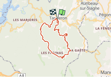

Length
16 km

Max alt
484 m

Uphill gradient
579 m
Km-Effort
24 km

Min alt
155 m

Downhill gradient
580 m
Boucle
Yes
Creation date :
2024-03-06 07:26:32.0
Updated on :
2024-03-06 14:24:16.491

FREE GPS app for hiking
 SityTrail
IGN / Geographical institutes
SityTrail Plus
The world is yours!
About
Trail of 16 km to be discovered at Provence-Alpes-Côte d'Azur, Var, Tanneron. This trail is proposed by GeorgesV..
Positioning
Country:
France
Region :
Provence-Alpes-Côte d'Azur
Department/Province :
Var
Municipality :
Tanneron
Location:
Unknown
Start:(Dec)
Start:(UTM)
328459 ; 4828439 (32T) N.
Comments