


dulphey

mcterret
User
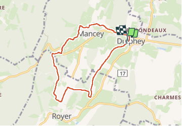

Length
7.4 km

Max alt
385 m

Uphill gradient
192 m
Km-Effort
9.9 km

Min alt
242 m

Downhill gradient
195 m
Boucle
Yes
Creation date :
2024-03-06 13:49:15.962
Updated on :
2024-03-06 16:04:07.003
1h56
Difficulty : Easy

FREE GPS app for hiking
 SityTrail
IGN / Geographical institutes
SityTrail Plus
The world is yours!
About
Trail Walking of 7.4 km to be discovered at Bourgogne-Franche-Comté, Saône-et-Loire, Mancey. This trail is proposed by mcterret.
Positioning
Country:
France
Region :
Bourgogne-Franche-Comté
Department/Province :
Saône-et-Loire
Municipality :
Mancey
Location:
Unknown
Start:(Dec)
Start:(UTM)
641416 ; 5159302 (31T) N.
Comments