


Dombes 2 bis

ophness
User
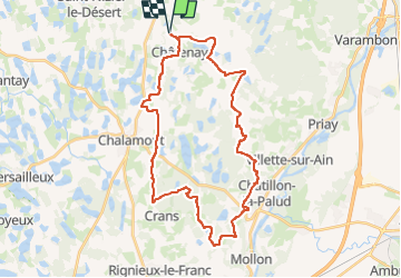

Length
35 km

Max alt
327 m

Uphill gradient
388 m
Km-Effort
40 km

Min alt
271 m

Downhill gradient
388 m
Boucle
Yes
Creation date :
2024-03-07 08:30:29.0
Updated on :
2024-03-07 08:30:30.611

FREE GPS app for hiking
 SityTrail
IGN / Geographical institutes
SityTrail Plus
The world is yours!
About
Trail of 35 km to be discovered at Auvergne-Rhône-Alpes, Ain, Châtenay. This trail is proposed by ophness.
Positioning
Country:
France
Region :
Auvergne-Rhône-Alpes
Department/Province :
Ain
Municipality :
Châtenay
Location:
Unknown
Start:(Dec)
Start:(UTM)
669866 ; 5101161 (31T) N.
Comments