


les costes grospierre

clintest
User
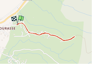

Length
1.8 km

Max alt
217 m

Uphill gradient
75 m
Km-Effort
2.8 km

Min alt
138 m

Downhill gradient
73 m
Boucle
Yes
Creation date :
2024-03-07 08:42:36.422
Updated on :
2024-03-07 09:20:36.487
37m
Difficulty : Easy

FREE GPS app for hiking
 SityTrail
IGN / Geographical institutes
SityTrail Plus
The world is yours!
About
Trail Walking of 1.8 km to be discovered at Auvergne-Rhône-Alpes, Ardèche, Grospierres. This trail is proposed by clintest.
Positioning
Country:
France
Region :
Auvergne-Rhône-Alpes
Department/Province :
Ardèche
Municipality :
Grospierres
Location:
Unknown
Start:(Dec)
Start:(UTM)
603688 ; 4918348 (31T) N.
Comments