


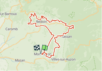
Territoire du Mont Ventoux

supercolas
User GUIDE

Length
47 km

Max alt
716 m

Uphill gradient
1045 m
Km-Effort
61 km

Min alt
220 m

Downhill gradient
1045 m
Boucle
Yes
Creation date :
2024-03-07 12:03:08.89
Updated on :
2024-03-08 11:06:02.769
3h27
Difficulty : Difficult

FREE GPS app for hiking
 SityTrail
IGN / Geographical institutes
SityTrail Plus
The world is yours!
About
Trail Mountain bike of 47 km to be discovered at Provence-Alpes-Côte d'Azur, Vaucluse, Mormoiron. This trail is proposed by supercolas.
Description
Ventoux Sud
Positioning
Country:
France
Region :
Provence-Alpes-Côte d'Azur
Department/Province :
Vaucluse
Municipality :
Mormoiron
Location:
Unknown
Start:(Dec)
Start:(UTM)
674572 ; 4881658 (31T) N.
Comments