


Tour de biot

Arnaud Stévenard
User
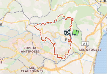

Length
18.2 km

Max alt
202 m

Uphill gradient
543 m
Km-Effort
25 km

Min alt
16 m

Downhill gradient
544 m
Boucle
Yes
Creation date :
2024-03-07 20:07:44.0
Updated on :
2024-03-07 20:07:45.463
5h47
Difficulty : Medium

FREE GPS app for hiking
 SityTrail
IGN / Geographical institutes
SityTrail Plus
The world is yours!
About
Trail Walking of 18.2 km to be discovered at Provence-Alpes-Côte d'Azur, Maritime Alps, Biot. This trail is proposed by Arnaud Stévenard.
Positioning
Country:
France
Region :
Provence-Alpes-Côte d'Azur
Department/Province :
Maritime Alps
Municipality :
Biot
Location:
Unknown
Start:(Dec)
Start:(UTM)
346718 ; 4832355 (32T) N.
Comments