


Le Suquet St Jean la Rivière côté G

Renefrt
User
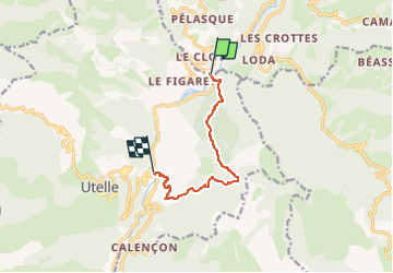

Length
7.8 km

Max alt
1012 m

Uphill gradient
667 m
Km-Effort
16.8 km

Min alt
300 m

Downhill gradient
708 m
Boucle
No
Creation date :
2024-03-08 09:04:22.243
Updated on :
2024-03-08 09:04:26.177
3h49
Difficulty : Medium

FREE GPS app for hiking
 SityTrail
IGN / Geographical institutes
SityTrail Plus
The world is yours!
About
Trail Walking of 7.8 km to be discovered at Provence-Alpes-Côte d'Azur, Maritime Alps, Lantosque. This trail is proposed by Renefrt.
Positioning
Country:
France
Region :
Provence-Alpes-Côte d'Azur
Department/Province :
Maritime Alps
Municipality :
Lantosque
Location:
Unknown
Start:(Dec)
Start:(UTM)
362205 ; 4866928 (32T) N.
Comments