


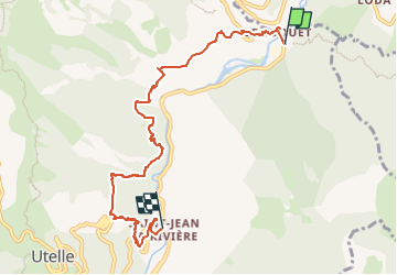
Le Suquet St Jean la Rivière

Renefrt
User

Length
7.5 km

Max alt
560 m

Uphill gradient
424 m
Km-Effort
13.4 km

Min alt
285 m

Downhill gradient
479 m
Boucle
No
Creation date :
2024-03-08 09:09:10.474
Updated on :
2024-03-08 09:09:14.159
3h02
Difficulty : Medium

FREE GPS app for hiking
 SityTrail
IGN / Geographical institutes
SityTrail Plus
The world is yours!
About
Trail Walking of 7.5 km to be discovered at Provence-Alpes-Côte d'Azur, Maritime Alps, Utelle. This trail is proposed by Renefrt.
Positioning
Country:
France
Region :
Provence-Alpes-Côte d'Azur
Department/Province :
Maritime Alps
Municipality :
Utelle
Location:
Unknown
Start:(Dec)
Start:(UTM)
362278 ; 4866758 (32T) N.
Comments