


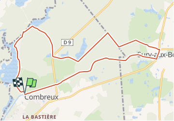
Combreux-Canal Orléans

astro45
User

Length
10.9 km

Max alt
147 m

Uphill gradient
86 m
Km-Effort
12 km

Min alt
121 m

Downhill gradient
87 m
Boucle
Yes
Creation date :
2024-03-08 14:07:43.91
Updated on :
2024-07-04 21:32:41.317
2h43
Difficulty : Medium

FREE GPS app for hiking
 SityTrail
IGN / Geographical institutes
SityTrail Plus
The world is yours!
About
Trail Walking of 10.9 km to be discovered at Centre-Loire Valley, Loiret, Combreux. This trail is proposed by astro45.
Description
Randonnée entre l'Etang de la Vallée, Sury-aux-Bois et retour par le canal d'Orléans.
Positioning
Country:
France
Region :
Centre-Loire Valley
Department/Province :
Loiret
Municipality :
Combreux
Location:
Unknown
Start:(Dec)
Start:(UTM)
447279 ; 5311605 (31T) N.
Comments