


Isere

JYDel
User
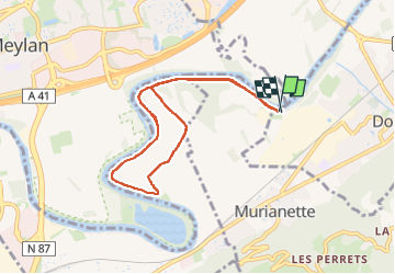

Length
8.3 km

Max alt
229 m

Uphill gradient
64 m
Km-Effort
9.2 km

Min alt
210 m

Downhill gradient
63 m
Boucle
Yes
Creation date :
2024-03-08 13:16:05.329
Updated on :
2024-03-08 15:02:51.805
1h38
Difficulty : Easy

FREE GPS app for hiking
 SityTrail
IGN / Geographical institutes
SityTrail Plus
The world is yours!
About
Trail Walking of 8.3 km to be discovered at Auvergne-Rhône-Alpes, Isère, Domène. This trail is proposed by JYDel.
Positioning
Country:
France
Region :
Auvergne-Rhône-Alpes
Department/Province :
Isère
Municipality :
Domène
Location:
Unknown
Start:(Dec)
Start:(UTM)
721419 ; 5009291 (31T) N.
Comments