


collet d'allevard

oliviergau
User
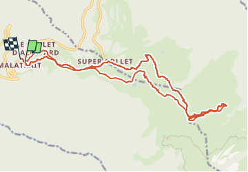

Length
12.2 km

Max alt
2087 m

Uphill gradient
1050 m
Km-Effort
26 km

Min alt
1408 m

Downhill gradient
1064 m
Boucle
Yes
Creation date :
2024-02-23 08:13:17.313
Updated on :
2024-03-09 14:22:42.905
4h24
Difficulty : Very easy

FREE GPS app for hiking
 SityTrail
IGN / Geographical institutes
SityTrail Plus
The world is yours!
About
Trail Touring skiing of 12.2 km to be discovered at Auvergne-Rhône-Alpes, Isère, Allevard. This trail is proposed by oliviergau.
Positioning
Country:
France
Region :
Auvergne-Rhône-Alpes
Department/Province :
Isère
Municipality :
Allevard
Location:
Unknown
Start:(Dec)
Start:(UTM)
273672 ; 5030700 (32T) N.
Comments