


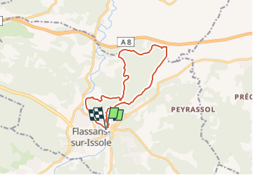
Flassans - Voie Romaine et Château des Ponteves

frizou83
User

Length
13.2 km

Max alt
318 m

Uphill gradient
264 m
Km-Effort
16.7 km

Min alt
217 m

Downhill gradient
263 m
Boucle
Yes
Creation date :
2024-03-09 22:07:59.223
Updated on :
2024-03-16 18:09:08.052
3h47
Difficulty : Difficult

FREE GPS app for hiking
 SityTrail
IGN / Geographical institutes
SityTrail Plus
The world is yours!
About
Trail Walking of 13.2 km to be discovered at Provence-Alpes-Côte d'Azur, Var, Flassans-sur-Issole. This trail is proposed by frizou83.
Positioning
Country:
France
Region :
Provence-Alpes-Côte d'Azur
Department/Province :
Var
Municipality :
Flassans-sur-Issole
Location:
Unknown
Start:(Dec)
Start:(UTM)
274879 ; 4805698 (32T) N.
Comments