


Chaumes en Retz 2024

Lobin
User

Length
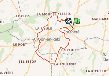
16.2 km

Max alt
29 m

Uphill gradient
86 m
Km-Effort
17.3 km

Min alt
4 m

Downhill gradient
88 m
Boucle
Yes
Creation date :
2024-03-10 08:15:17.0
Updated on :
2024-03-10 12:20:56.734
2h46
Difficulty : Medium

FREE GPS app for hiking
 SityTrail
IGN / Geographical institutes
SityTrail Plus
The world is yours!
About
Trail Walking of 16.2 km to be discovered at Pays de la Loire, Loire-Atlantique, Chaumes-en-Retz. This trail is proposed by Lobin.
Positioning
Country:
France
Region :
Pays de la Loire
Department/Province :
Loire-Atlantique
Municipality :
Chaumes-en-Retz
Location:
Chéméré
Start:(Dec)
Start:(UTM)
582500 ; 5219690 (30T) N.
Comments