


boucle Sondern

Lychee
User
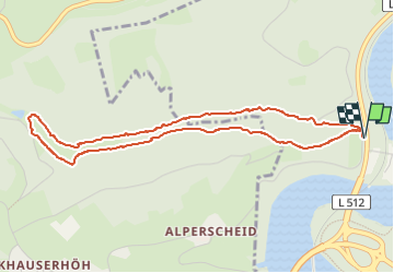

Length
4.4 km

Max alt
405 m

Uphill gradient
95 m
Km-Effort
5.6 km

Min alt
329 m

Downhill gradient
93 m
Boucle
Yes
Creation date :
2024-03-10 13:43:24.026
Updated on :
2024-03-10 15:19:46.027
1h36
Difficulty : Easy

FREE GPS app for hiking
 SityTrail
IGN / Geographical institutes
SityTrail Plus
The world is yours!
About
Trail Walking of 4.4 km to be discovered at North Rhine-Westphalia, Kreis Olpe, Olpe. This trail is proposed by Lychee.
Positioning
Country:
Germany
Region :
North Rhine-Westphalia
Department/Province :
Kreis Olpe
Municipality :
Olpe
Location:
Unknown
Start:(Dec)
Start:(UTM)
418125 ; 5655758 (32U) N.
Comments