


Reprise Col de Tourniol

lmc
User
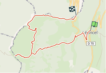

Length
10.5 km

Max alt
1299 m

Uphill gradient
542 m
Km-Effort
16.9 km

Min alt
918 m

Downhill gradient
312 m
Boucle
No
Creation date :
2024-03-11 09:54:50.789
Updated on :
2024-03-11 09:56:22.156
3h50
Difficulty : Unknown

FREE GPS app for hiking
 SityTrail
IGN / Geographical institutes
SityTrail Plus
The world is yours!
About
Trail Walking of 10.5 km to be discovered at Auvergne-Rhône-Alpes, Drôme, Léoncel. This trail is proposed by lmc.
Positioning
Country:
France
Region :
Auvergne-Rhône-Alpes
Department/Province :
Drôme
Municipality :
Léoncel
Location:
Unknown
Start:(Dec)
Start:(UTM)
673070 ; 4975520 (31T) N.
Comments