


Amange

pje
User
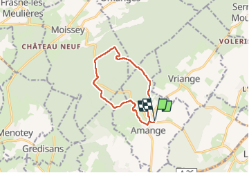

Length
9.8 km

Max alt
376 m

Uphill gradient
236 m
Km-Effort
13 km

Min alt
221 m

Downhill gradient
236 m
Boucle
Yes
Creation date :
2024-03-11 07:59:40.964
Updated on :
2024-03-11 10:45:51.258
2h45
Difficulty : Medium

FREE GPS app for hiking
 SityTrail
IGN / Geographical institutes
SityTrail Plus
The world is yours!
About
Trail Walking of 9.8 km to be discovered at Bourgogne-Franche-Comté, Jura, Amange. This trail is proposed by pje.
Positioning
Country:
France
Region :
Bourgogne-Franche-Comté
Department/Province :
Jura
Municipality :
Amange
Location:
Unknown
Start:(Dec)
Start:(UTM)
694626 ; 5226810 (31T) N.
Comments